C31 Crakehill Bank roadworks
The C31 Crakehill Bank is situated between Hamsterley and Witton-le-Wear and is also one of the access routes to Hamsterley Forest.
A local diversion route is in place during the closure. This will be via the A68, Toft Hill, Diddridge Lane, Daniel Lane and the C30. This diversion is 4.5 miles. See One Network: Crakehill Bank Diversion for details.
Background
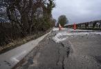
The road had been subject to temporary traffic lights for a considerable amount of time to protect the carriageway from further damage caused by the embankment being unstable. Following ground investigation works and further slippage of the carriageway and embankment, a decision was made to close the road to all traffic in the interests of public safety.

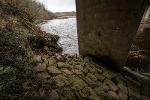
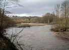
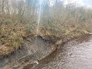
We are also aware of ongoing erosion to the top of the southern embankment both adjacent to the road closure and further downstream including in the vicinity of the A68 bridge. This has caused some minor damage to the southern apron adjacent to the bridge pier. We are monitoring the situation whilst we investigate options to protect the bridge.
The road has been closed since January 2023, to accommodate specialist ground investigation contractors who have been examining the sub-surface conditions beneath the road and also assessing the stability of the embankment.
Current programme
- Road closure and diversion in place: 23 January 2023 - Complete
- Ground investigation underway: 23 January 2023 - June 2023 - Complete
- Options report due: end of June 2023 - Complete
- Consider design solutions: June 2023 - Complete
- Design consultant appointed: February 2024 - Complete
- Extensive feasibility studies carried out by Design Consultant: September/October 2024 - Complete
- Detailed design: Paused whilst alternative options are considered
- Planning permission: Paused
- Construction tender: Paused
Work undertaken so far
October 2024
We have continued to work with our design consultants to undertake further surveys and evaluate the extent of the embankment slippage. These surveys have confirmed the existing slippage has continued to deteriorate and has now extended further towards the A68 junction. We are currently considering alternative options. In the meantime, additional site safety measures have been introduced to ensure public safety.
February 2024
The procurement exercise to engage with a design consultant has concluded and an appointment has been made allowing detailed design of the road realignment and associated drainage works to be progressed, with design completion anticipated by the end of May. Land negotiations will run concurrently with the detailed design programme. Once design is completed, this will allow the planning application to be submitted whilst the construction tender is progressed over the summer. The existing carriageway continues to fail and further plans are underway to ensure the site is fully restricted.
August 2023
After assessing a range of potential solutions, our preferred option is to divert the carriageway south of its current position. This will require land acquisition and initial discussions have been held with the adjoining landowner to move forward land negotiations.
The road will remain closed in the short to medium term while the detailed design solution is progressed.
June 2023
Transcript Cracking on Crakehill C31 (PDF, 52 KB)
Specialist ground investigation consultants have now completed monitoring of the ground on the embankment and under the road at the C31.
The results show the presence of a water table over 3m below the carriageway surface which is contributing to the instability issues faced. Ground water is presenting at various locations on the embankment causing the area to move and destabilising the highway leading to cracking.
We are now engaging with specialist designers to explore potential solutions, and progress with a preferred design option and estimate. We are currently assessing potential solutions and exploring funding opportunities.
Our options include:
- Diversion of the existing carriageway (subject to discussions with adjoining landowners)
- A piled retaining wall
- Use of soil nails on the embankment (subject to discussions with adjoining landowners)
- Implementing a scheme that addresses and diverts the water table away from the embankment (subject to discussions with adjoining landowners)
We are continuing to monitor the movement of the carriageway and following our latest review where further movement and damage has been observed we are continuing to keep the C31 closed to all traffic in the interests of public safety.
January 2023
Ground investigation works involved the excavation of the surface of the road and surrounding areas to core into the sub-strata. The results of which identified the presence of a water table that is approximately 3.5m beneath the surface of the road. The impact of ground water at this level has caused significant embankment subsidence and structural failure of the road.
Additional topographic survey and investigation of the embankment slope to establish the make-up of the ground and to identify any weak points.
How long it will take
We are looking to appoint a specialist consultant to undertake the necessary design feasibility study to identify a potential long-term solution. This will take time as further on-site surveys will be required.
In the meantime, the road will remain closed for the foreseeable future. We would like to thank road users and residents for their patience as we identify a potential solution.


 Share this page on Facebook
 Share this page on Twitter
 Print this page


